Click HERE to
plan your own route on a larger map!
|
Maps and Directions
It might be a bit of a hot and
bumpy ride, but rest assured, your hot tub will be ready for you when
you arrive! Guadalupe Canyon Oasis is located southwest of the city of
Mexicali in Northern Baja California, Mexico. We are located just 50
miles southwest of
Mexicali and 135 miles
southeast of Tijuana, off Highway 2.
From the states, the most popular routes are through the border towns
of Tecate and Mexicali.
To the left, you will find an interactive Google Maps tool on which
Guadalupe Canyon Oasis is pinpointed. Our most popular routes are
highlighted on this map and also described below. You can also click
below the map to find your own location and plan your route accordingly!
We suggest that you purchase Baja car insurance before you come. Guadalupe Canyon is off the beaten track, so the extra peace of mind will be well worth it. Bajabound.com has plans available specifically for Baja driving that are very affordable and can be purchased by the day. This will ensure that your vehicle stays safe while it's across the border. We know the faces behind the company name, and they're good people who will take care of you.

Don't hesitate to call upon our Shuttle service if the
directions sound too adventurous.
From California through
Mexicali or Calexico
This
route is the easiest for those who are unfamilar with driving in Mexico
and want to take the simplest, most direct route to Guadalupe Canyon
Oasis. We also recommend this route for those traveling from or through
Los Angeles since traffic is usually milder than on the I-405/I-5 to
San Diego. In addition, this route is free of toll-booth charges,
unlike the Tecate route.
- Take I-5, I-405, 91 East, 60 East, or 210 East as needed to
reach I-10 East.
- Merge onto the I-10 East towards Indio.
- Continue just past the city of Indio, and exit onto Hwy 86
South towards El Centro.
- After 70 miles, turn right to continue on Hwy 86/South 1st
St. Continue to follow Hwy 86.
- Merge onto I-8 East.
- After 4 miles, exit onto Hwy 111 South
towards Calexico/Mexicali. Be sure to take a break to make sure you
have all necessary
gas, water, ice, and food supplies in Calexico before crossing the
border since services are harder to find after this.
- Cross the Calexico/Mexical border. This border crossing is
usually very quick in this direction, but can sometimes be busy. The
crossing is open 24 hours a day.
- Once you cross the border at Mexicali, head south on Calle
Guadalajara (through a section of downtown Mexicali)
for about 5 miles, following signs to Mexico Highway 2. Merge onto
Highway 2 West (towards Tecate/Tijuana).
- After about 15 miles, you will begin to cross the surface
of the Dry Lake Bed. The first junction for "CAÑÓN DE GUADALUPE" that
you will encounter is
the Dry Lake Route. Continue on 2.7 miles if you wish to take the
Graded Dirt Route. See below
to decide which route to take.
From California through
Tecate
If
you are coming from the San Diego area, this is the fastest route to
arrive at Guadalupe Canyon Oasis. The Tecate border crossing is quiet,
and is open from 5 A.M. to 11 P.M. This route includes a toll road and rock garden scenery
- From I-5 Southbound, take exit 15B for Hwy 94/ MLK Jr.
Freeway.
- Merge onto Hwy 94 East.
- After 13 miles, turn right to stay on Hwy 94 East/Campo Rd. Continue on Hwy 94 East to Hwy 188
- Turn right on Hwy 188/Tecate Rd. This should take you right
to the border crossing.
- You will emerge from the border crossing onto Calle
Presidente Lazaro Cardenas, heading south.
Two blocks south of the border, turn left onto Calle Benito Juarez
past the beautiful plaza of Tecate.
- Make an immediate right onto Calle Presidente Pascal Ortiz
Rubio, and continue south on this highway.
- After about 1.5 miles and at the top of the hill, you will
encounter the "cuota," or
toll road, Highway 2, which runs East (Mexicali)/West (Tijuana). Take
the toll
highway East towards Mexicali.
- After approximately 30 miles, you will pass through a small
town called La Rumorosa (your very last chance for supplies!) and begin
to descend through a scenic rock garden for several miles. The road is
steep and the views are beautiful. The current toll rate is 20 pesos
paid at the toll booth.
- You will emerge from the rock garden onto a very large flat
expanse. This is the beginning of the Dry Lake Bed. After about six
miles you will come to a safety check point, in most instances you will
waved on. In about four miles will notice the turn off sign junction
for "CAÑÓN DE GUADALUPE". This is
the Graded Dirt Route that is recommended for first time visitors.
Continue on 2.7 miles if you wish to take the
Dry Lake Route. See below to
decide which route to take!
Once at
Mexico Highway 2
West
- There are two roads leading to Guadalupe Canyon Oasis
from Highway 2. They eventually merge back together. THE GRADED DIRT
ROAD IS THE RECOMMENDED ROUTE FOR THOSE COMING FOR THE FIRST TIME.
Please read the
route descriptions carefully in order to choose the best option for
your trip. Please contact us for more information and current road
conditions!
- Dry Lake
(eastern) Route:
Follow Highway 2 West for 20
miles to the first "CAÑÓN DE GUADALUPE" junction. This is the entrance
to the eastern dirt road that leads 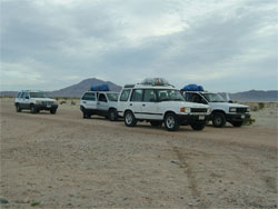 south to Guadalupe Canyon Oasis.
This junction can only be entered from the east lane, so once you pass
the overhead sign, you will need to
circle-back using the first available U-turn lane.
south to Guadalupe Canyon Oasis.
This junction can only be entered from the east lane, so once you pass
the overhead sign, you will need to
circle-back using the first available U-turn lane.
This route is usually the smoother and faster of the two, but travels
through the dry lakebed of Laguna Salada and can be muddy in places if
it has rained recently. Generally, we prefer this road if conditions
permit, but please be wary of the possibility of getting stuck in the
mud. Please note that you may see multiple "lanes" or tracks along this
road. Don't get nervous, just pick the best available lane, heading
south and slightly west, and keep an eye out for the "CAÑÓN DE
GUADALUPE" signs designed to keep you on track. All roads eventually
lead toward Guadalupe Canyon, so you will arrive safely if you stay
vigilant. (It is NOT a good idea to attempt this route at night
unless you are very familiar with the road!)
- Graded Dirt
(western) Route:
Follow Highway 2 West to the first "CAÑÓN DE GUADALUPE" junction. Pass
this junction
sign This is the entrance to the western dirt road that leads to
Guadalupe
Canyon Oasis and is recommended for first time visitors.
This route is the more "official" road to Guadalupe Canyon
Oasis, and
is slightly higher in elevation, but suffers from some patches of bumpy
washboard and sand, and therefore is a little slower than
the Dry Lake Route. Nevertheless, this road is generally the safer,
surer route if the eastern route is likely to be muddy. If in doubt
please call our travel office.
- Once the two routes merge back together, the last segment
of 7 miles begins as a
mostly smooth but increasingly winding dirt road.
- Following this, there is a final half-mile or so of rocky
road. SUVs and trucks with good
ground clearance are recommended and tend to do best. However, with a
bit of
 cautious
driving, two
wheel-drive vehicles with
good ground clearance should be able to make it without trouble.
cautious
driving, two
wheel-drive vehicles with
good ground clearance should be able to make it without trouble.
- 4. Go straight and continue on this road. See the green
sign with the "Guadalupe Canyon Oasis" and website name on it and the
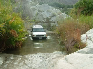
arrow that points straight ahead to the hot springs. Once at the hot
springs here is a small creek that crosses the road, and is less than 6
inches deep. This is an easy crossing.
- Be sure to and bear left
(straight) at the
fork, following signs to "Guadalupe Canyon Oasis". This is a large
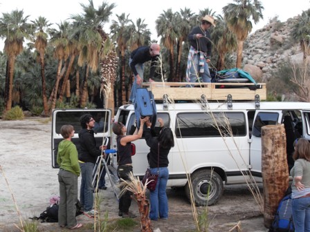
green sign. The Guadalupe Canyon Oasis main
office is located here where Ernesto Loya and his family will welcome
you and check you in.
|